Geolocate

Tangmarg topographic map

Click on the map to display elevation.

About this map

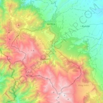
Name: Tangmarg topographic map, elevation, terrain.

Location: Tangmarg, Baramulla district, Jammu and Kashmir, India (33.90593 74.28389 34.12854 74.60424)

Average elevation: 9,108 ft

Minimum elevation: 5,289 ft

Maximum elevation: 15,013 ft

Other topographic maps

Click on a map to view its topography, its elevation and its terrain.

Monkey Hills

India > Jammu and Kashmir > Tangmarg > Gulmarg

Average elevation: 8,615 ft

Gear up for your next adventure:

🪶Compact Camp Shovel - Folding shovel for campsite tasks
🧤Tactile Hiking Gloves - Keep hands warm while operating GPS and smartphone screens
🧣Merino Neck Gaiters - Multi-functional headwear for wind and sun protection
🌡️Portable Weather Meter - Track weather conditions on the trail
📱Solar Portable Charger - Solar power bank for charging devices off‑grid

As an Amazon Associate, this site earns from qualifying purchases at no extra cost to you.