
Thank you for supporting this site ❤️
Make a donation
Make a donation
Gear up for your next adventure:
As an Amazon Associate, this site earns from qualifying purchases at no extra cost to you.
Galhano topographic map
Click on the map to display elevation.
Thank you for supporting this site ❤️
Make a donation
Make a donation
Gear up for your next adventure:
As an Amazon Associate, this site earns from qualifying purchases at no extra cost to you.
About this map
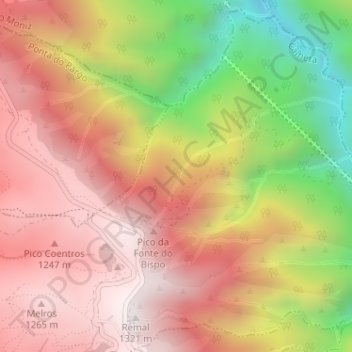
Name: Galhano topographic map, elevation, terrain.
Location: Galhano, Fajã da Ovelha, Calheta, Madeira, 9270, Portugal (32.78916 -17.18613 32.80916 -17.16613)
Average elevation: 2,959 ft
Minimum elevation: 955 ft
Maximum elevation: 4,301 ft
Thank you for supporting this site ❤️
Make a donation
Make a donation
Gear up for your next adventure:
As an Amazon Associate, this site earns from qualifying purchases at no extra cost to you.