Geolocate

Monroe topographic map

Click on the map to display elevation.

About this map

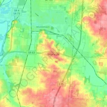
Name: Monroe topographic map, elevation, terrain.

Location: Monroe, Butler County, Ohio, United States (39.40975 -84.43664 39.47850 -84.29253)

Average elevation: 725 ft

Minimum elevation: 604 ft

Maximum elevation: 899 ft

Butler County trails, hiking, mountain biking, running and outdoor activities

Other topographic maps

Click on a map to view its topography, its elevation and its terrain.

Hughes

United States > Ohio > Butler County

Average elevation: 778 ft

South Highlands

United States > Ohio > Butler County > Middletown

Average elevation: 702 ft

Busenbark

United States > Ohio > Butler County

Average elevation: 663 ft

Williamsdale

United States > Ohio > Butler County

Average elevation: 633 ft

McGonigle

United States > Ohio > Butler County

Average elevation: 873 ft

Astoria

United States > Ohio > Butler County

Average elevation: 863 ft

West Chester

United States > Ohio > Butler County > West Chester

Average elevation: 758 ft

Gear up for your next adventure:

🌐World Map Poster - Decorative world maps with topographic info
🏕️Family Camping Gear - Essentials for group camping trips
🪶Paracord Bracelet - Survival bracelet with built‑in tools
🧺Microfiber Travel Towels - Compact and fast-drying towels for trail use
👟Trail Running Shoes - Lightweight shoes for trail runners

As an Amazon Associate, this site earns from qualifying purchases at no extra cost to you.