Geolocate

Thalawa topographic map

Click on the map to display elevation.

About this map

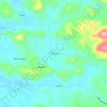
Name: Thalawa topographic map, elevation, terrain.

Location: Thalawa, Galle District, Southern Province, Sri Lanka (6.12001 80.27126 6.16001 80.31126)

Average elevation: 167 ft

Minimum elevation: 33 ft

Maximum elevation: 653 ft

Gear up for your next adventure:

🔭Telescopic Hiking Pole - Adjustable pole for hiking stability
📷Action Camera - Capture your outdoor adventures in HD
📖Nature Tracking Books - Learn to track wildlife and terrain
🧭Hiking Compass - Precision compass for reliable navigation in the wilderness
🪶Thermal Camp Blanket - Extra warmth for cold nights

As an Amazon Associate, this site earns from qualifying purchases at no extra cost to you.