
Make a donation
Gear up for your next adventure:
As an Amazon Associate, this site earns from qualifying purchases at no extra cost to you.
Chinácota topographic map
Click on the map to display elevation.
Make a donation
Gear up for your next adventure:
As an Amazon Associate, this site earns from qualifying purchases at no extra cost to you.
Chinácota
Su temperatura media es 22 grados Celsius, su altitud va desde los 600 a los 3200 m s. n. m. y su población es de 15 378 habitantes, de los cuales 8732 residen en la cabecera municipal y 6142 residen en el área rural.
Make a donation
Gear up for your next adventure:
As an Amazon Associate, this site earns from qualifying purchases at no extra cost to you.
About this map
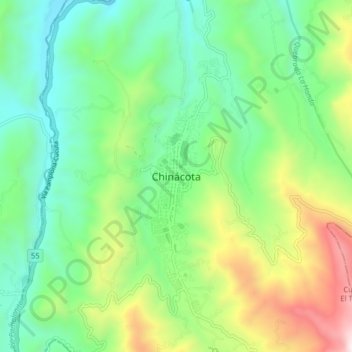
Name: Chinácota topographic map, elevation, terrain.
Location: Chinácota, Suroriente, Norte de Santander, J953+QM, Colombia (7.56840 -72.64037 7.64840 -72.56037)
Average elevation: 4,341 ft
Minimum elevation: 2,785 ft
Maximum elevation: 7,743 ft
Make a donation
Gear up for your next adventure:
As an Amazon Associate, this site earns from qualifying purchases at no extra cost to you.