
Make a donation
Gear up for your next adventure:
As an Amazon Associate, this site earns from qualifying purchases at no extra cost to you.
Villa de Cura topographic map
Click on the map to display elevation.
Make a donation
Gear up for your next adventure:
As an Amazon Associate, this site earns from qualifying purchases at no extra cost to you.
Villa de Cura
Villa de Cura posee una superficie de 448 km² y está ubicada a una altitud de 526 m s. n. m., medidos en la iglesia matriz, mientras que su altitud baja a 521,71 m s. n. m. desde la Plaza Bolívar. Está enclavada en un valle entre ríos actualmente secos: El río Curita (antiguamente llamado Cura, motivo del nombre de la ciudad), río Tucutunemo y río Las Minas.
Make a donation
Gear up for your next adventure:
As an Amazon Associate, this site earns from qualifying purchases at no extra cost to you.
About this map
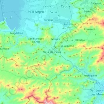
Name: Villa de Cura topographic map, elevation, terrain.
Average elevation: 2,182 ft
Minimum elevation: 1,319 ft
Maximum elevation: 5,810 ft
Make a donation
Gear up for your next adventure:
As an Amazon Associate, this site earns from qualifying purchases at no extra cost to you.
Other topographic maps
Click on a map to view its topography, its elevation and its terrain.
Río Guárico
Venezuela > Estado Aragua > Municipio Zamora > San Juan de Los Morros
Average elevation: 1,476 ft
Plaza Bolívar
Venezuela > Estado Aragua > Municipio Zamora > Villa de Cura
Average elevation: 1,821 ft
Make a donation
Gear up for your next adventure:
As an Amazon Associate, this site earns from qualifying purchases at no extra cost to you.