
Thank you for supporting this site ❤️
Make a donation
Make a donation
Gear up for your next adventure:
As an Amazon Associate, this site earns from qualifying purchases at no extra cost to you.
Vilar topographic map
Click on the map to display elevation.
Thank you for supporting this site ❤️
Make a donation
Make a donation
Gear up for your next adventure:
As an Amazon Associate, this site earns from qualifying purchases at no extra cost to you.
About this map
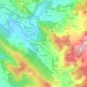
Name: Vilar topographic map, elevation, terrain.
Location: Vilar, Sobreira, Paredes, Porto, 4585-720, Portugal (41.11909 -8.39954 41.15909 -8.35954)
Average elevation: 568 ft
Minimum elevation: 249 ft
Maximum elevation: 1,063 ft
Thank you for supporting this site ❤️
Make a donation
Make a donation
Gear up for your next adventure:
As an Amazon Associate, this site earns from qualifying purchases at no extra cost to you.