
Make a donation
Gear up for your next adventure:
As an Amazon Associate, this site earns from qualifying purchases at no extra cost to you.
Larmkogel topographic map
Click on the map to display elevation.
Make a donation
Gear up for your next adventure:
As an Amazon Associate, this site earns from qualifying purchases at no extra cost to you.
Larmkogel
Der Larmkogel ist ein Berg in der Venedigergruppe mit einer Höhe von 3017 m ü. A. im Bundesland Salzburg.
Make a donation
Gear up for your next adventure:
As an Amazon Associate, this site earns from qualifying purchases at no extra cost to you.
About this map
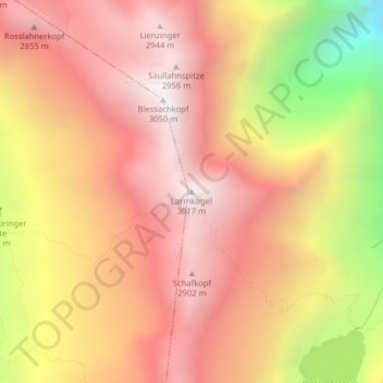
Name: Larmkogel topographic map, elevation, terrain.
Average elevation: 8,084 ft
Minimum elevation: 4,925 ft
Maximum elevation: 9,856 ft
Make a donation
Gear up for your next adventure:
As an Amazon Associate, this site earns from qualifying purchases at no extra cost to you.
Other topographic maps
Click on a map to view its topography, its elevation and its terrain.
Hollersbach
Österreich > Salzburg > Bezirk Zell am See > Hollersbach im Pinzgau
Average elevation: 5,745 ft