
Thank you for supporting this site ❤️
Make a donation
Make a donation
Gear up for your next adventure:
As an Amazon Associate, this site earns from qualifying purchases at no extra cost to you.
Mazocruz topographic map
Click on the map to display elevation.
Thank you for supporting this site ❤️
Make a donation
Make a donation
Gear up for your next adventure:
As an Amazon Associate, this site earns from qualifying purchases at no extra cost to you.
About this map
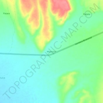
Name: Mazocruz topographic map, elevation, terrain.
Location: Mazocruz, Candarave, Tacna, Perú (-16.90236 -70.33745 -16.86236 -70.29745)
Average elevation: 14,728 ft
Minimum elevation: 14,649 ft
Maximum elevation: 14,902 ft
Thank you for supporting this site ❤️
Make a donation
Make a donation
Gear up for your next adventure:
As an Amazon Associate, this site earns from qualifying purchases at no extra cost to you.