Geolocate

Gaiola topographic map

Click on the map to display elevation.

About this map

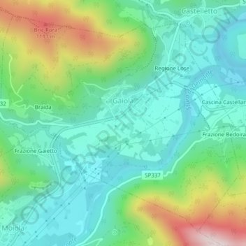
Name: Gaiola topographic map, elevation, terrain.

Location: Gaiola, Cuneo, Piedmont, Italy (44.32075 7.38674 44.34473 7.42480)

Average elevation: 2,608 ft

Minimum elevation: 2,064 ft

Maximum elevation: 3,960 ft

Other topographic maps

Click on a map to view its topography, its elevation and its terrain.

Viozene

Italy > Piedmont > Cuneo > Ormea

Average elevation: 5,059 ft

Ciampetti

Italy > Piedmont > Cuneo > Ostana

Average elevation: 4,324 ft

Vasco

Italy > Piedmont > Cuneo > Monastero di Vasco

Average elevation: 1,788 ft

Gear up for your next adventure:

🌡️Handheld Weather Meters - Measure wind, temp, and pressure for safe mountain travel
🗃️Trail First Aid Kit - Essential kit for outdoor injuries and emergencies
🔥Fast-Boil Camping Stoves - Efficient cooking systems for quick trail meals
🏕️Family Camping Gear - Essentials for group camping trips
🧴Hand Sanitizer - Keep hands clean while hiking

As an Amazon Associate, this site earns from qualifying purchases at no extra cost to you.