
Make a donation
Gear up for your next adventure:
As an Amazon Associate, this site earns from qualifying purchases at no extra cost to you.
Avenue topographic map
Click on the map to display elevation.
Make a donation
Gear up for your next adventure:
As an Amazon Associate, this site earns from qualifying purchases at no extra cost to you.
About this map
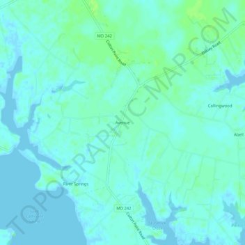
Name: Avenue topographic map, elevation, terrain.
Location: Avenue, Saint Mary's County, Maryland, 20609, United States (38.23624 -76.78775 38.27624 -76.74775)
Average elevation: 10 ft
Minimum elevation: -13 ft
Maximum elevation: 33 ft
Make a donation
Gear up for your next adventure:
As an Amazon Associate, this site earns from qualifying purchases at no extra cost to you.
Other topographic maps
Click on a map to view its topography, its elevation and its terrain.
Mechanicsville
United States > Maryland > Saint Mary's County > Mechanicsville
Average elevation: 151 ft
St. George Island
United States > Maryland > Saint Mary's County > Piney Point > Saint George Island
Average elevation: 0 ft
Make a donation
Gear up for your next adventure:
As an Amazon Associate, this site earns from qualifying purchases at no extra cost to you.
Charlotte Hall
United States > Maryland > Saint Mary's County > Charlotte Hall
Average elevation: 161 ft
Lexington Park
United States > Maryland > Saint Mary's County > Lexington Park
Average elevation: 79 ft
Lexington Park
United States > Maryland > Saint Mary's County > Lexington Park
Average elevation: 79 ft
Make a donation
Gear up for your next adventure:
As an Amazon Associate, this site earns from qualifying purchases at no extra cost to you.
Mechanicsville
United States > Maryland > Saint Mary's County > Mechanicsville
Average elevation: 151 ft
Lexington Park
United States > Maryland > Saint Mary's County > Lexington Park
Average elevation: 79 ft
Make a donation
Gear up for your next adventure:
As an Amazon Associate, this site earns from qualifying purchases at no extra cost to you.