
Make a donation
Gear up for your next adventure:
As an Amazon Associate, this site earns from qualifying purchases at no extra cost to you.
Sea Ranch Lakes topographic map
Click on the map to display elevation.
Make a donation
Gear up for your next adventure:
As an Amazon Associate, this site earns from qualifying purchases at no extra cost to you.
About this map
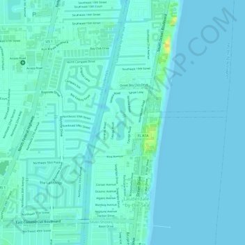
Name: Sea Ranch Lakes topographic map, elevation, terrain.
Location: Sea Ranch Lakes, Broward County, Florida, United States (26.19696 -80.10197 26.20453 -80.08538)
Average elevation: 16 ft
Minimum elevation: 0 ft
Maximum elevation: 82 ft
Broward County trails, hiking, mountain biking, running and outdoor activities
Make a donation
Gear up for your next adventure:
As an Amazon Associate, this site earns from qualifying purchases at no extra cost to you.
Other topographic maps
Click on a map to view its topography, its elevation and its terrain.
South Fork New River
United States > Florida > Broward County > Fort Lauderdale
Average elevation: 23 ft
Make a donation
Gear up for your next adventure:
As an Amazon Associate, this site earns from qualifying purchases at no extra cost to you.
Santa Barbara Shores
United States > Florida > Broward County > Pompano Beach
Average elevation: 16 ft
Make a donation
Gear up for your next adventure:
As an Amazon Associate, this site earns from qualifying purchases at no extra cost to you.
Southwest Ranches
United States > Florida > Broward County > Southwest Ranches
Average elevation: 16 ft
Birch Ocean Front
United States > Florida > Broward County > Fort Lauderdale > Birch Ocean Front
Average elevation: 13 ft
Make a donation
Gear up for your next adventure:
As an Amazon Associate, this site earns from qualifying purchases at no extra cost to you.
Coral Ridge
United States > Florida > Broward County > Fort Lauderdale > Coral Ridge
Average elevation: 16 ft
Make a donation
Gear up for your next adventure:
As an Amazon Associate, this site earns from qualifying purchases at no extra cost to you.
Pompano Beach Highlands
United States > Florida > Broward County > Pompano Beach
Average elevation: 23 ft
Fort Lauderdale Beach
United States > Florida > Broward County > Fort Lauderdale > Birch Ocean Front
Average elevation: 10 ft
Make a donation
Gear up for your next adventure:
As an Amazon Associate, this site earns from qualifying purchases at no extra cost to you.
Make a donation
Gear up for your next adventure:
As an Amazon Associate, this site earns from qualifying purchases at no extra cost to you.