Geolocate

Rabon topographic map

Click on the map to display elevation.

About this map

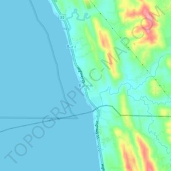
Name: Rabon topographic map, elevation, terrain.

Location: Rabon, La Union, Ilocos Region, Philippines (16.19180 120.39556 16.23180 120.43556)

Average elevation: 66 ft

Minimum elevation: -3 ft

Maximum elevation: 358 ft

Gear up for your next adventure:

🦟Ultrasonic Repellers - Create a bug-free zone at your camp or rest stop
🖼️Topo Map Wall Art - Decorative topographic prints of famous peaks and regions
📡GPS Antenna Upgrade - Enhance GPS reception in remote terrain
🔌USB Car Charger - Car charger for on‑the‑go power needs
🪵Folding Camp Saw - Compact saw for wood and campsite work

As an Amazon Associate, this site earns from qualifying purchases at no extra cost to you.