
Thank you for supporting this site ❤️
Make a donation
Make a donation
Gear up for your next adventure:
As an Amazon Associate, this site earns from qualifying purchases at no extra cost to you.
Efringen-Kirchen topographic map
Click on the map to display elevation.
Thank you for supporting this site ❤️
Make a donation
Make a donation
Gear up for your next adventure:
As an Amazon Associate, this site earns from qualifying purchases at no extra cost to you.
Efringen-Kirchen
Efringen-Kirchen liegt in der Oberrheinebene in 240 bis 396 Meter Höhe und grenzt direkt an den Rhein, der hier die Grenze zu Frankreich bildet. Es ist Teil des Markgräfler Landes.
Thank you for supporting this site ❤️
Make a donation
Make a donation
Gear up for your next adventure:
As an Amazon Associate, this site earns from qualifying purchases at no extra cost to you.
About this map
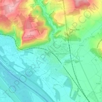
Name: Efringen-Kirchen topographic map, elevation, terrain.
Average elevation: 925 ft
Minimum elevation: 745 ft
Maximum elevation: 1,293 ft
Thank you for supporting this site ❤️
Make a donation
Make a donation
Gear up for your next adventure:
As an Amazon Associate, this site earns from qualifying purchases at no extra cost to you.