
Thank you for supporting this site ❤️
Make a donation
Make a donation
Gear up for your next adventure:
As an Amazon Associate, this site earns from qualifying purchases at no extra cost to you.
Paüls topographic map
Click on the map to display elevation.
Thank you for supporting this site ❤️
Make a donation
Make a donation
Gear up for your next adventure:
As an Amazon Associate, this site earns from qualifying purchases at no extra cost to you.
About this map
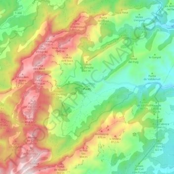
Name: Paüls topographic map, elevation, terrain.
Location: Paüls, Baix Ebre, Tarragona, Catalonia, 43593, Spain (40.88082 0.36026 40.96513 0.46703)
Average elevation: 1,706 ft
Minimum elevation: 285 ft
Maximum elevation: 3,766 ft
Thank you for supporting this site ❤️
Make a donation
Make a donation
Gear up for your next adventure:
As an Amazon Associate, this site earns from qualifying purchases at no extra cost to you.