Geolocate

Wald topographic map

Click on the map to display elevation.

About this map

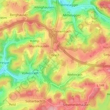
Name: Wald topographic map, elevation, terrain.

Location: Wald, Reichshof, Oberbergischer Kreis, North Rhine-Westphalia, 51580, Germany (50.94905 7.62383 50.98905 7.66383)

Average elevation: 997 ft

Minimum elevation: 741 ft

Maximum elevation: 1,217 ft

Other topographic maps

Click on a map to view its topography, its elevation and its terrain.

Gear up for your next adventure:

📚USA Hiking Guide Books - Top trail guides and map books
🧭Orienteering Set - Complete compass and map reading kit
🎒Trekking Poles - Sturdy poles for balance and stability on rough terrain
🔌USB Car Charger - Car charger for on‑the‑go power needs
🪵Folding Camp Saw - Compact saw for wood and campsite work

As an Amazon Associate, this site earns from qualifying purchases at no extra cost to you.