
Make a donation
Gear up for your next adventure:
As an Amazon Associate, this site earns from qualifying purchases at no extra cost to you.
Kamo topographic map
Click on the map to display elevation.
Make a donation
Gear up for your next adventure:
As an Amazon Associate, this site earns from qualifying purchases at no extra cost to you.
Kamo
Kamo is located in an inland region of north-central Niigata Prefecture. As the city name implies, the Kamo River flows through the city. The highest elevation is the summit of Mount Awagatake at 1292 meters. The city is located roughly halfway between the two larger cities of Nagaoka and Niigata.
Make a donation
Gear up for your next adventure:
As an Amazon Associate, this site earns from qualifying purchases at no extra cost to you.
About this map
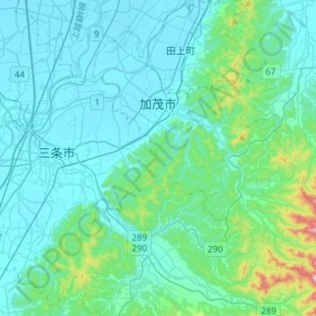
Name: Kamo topographic map, elevation, terrain.
Location: Kamo, Niigata Prefecture, Chubu Region, Japan (37.55311 138.98911 37.71061 139.23446)
Average elevation: 249 ft
Minimum elevation: 3 ft
Maximum elevation: 1,985 ft
Make a donation
Gear up for your next adventure:
As an Amazon Associate, this site earns from qualifying purchases at no extra cost to you.
Other topographic maps
Click on a map to view its topography, its elevation and its terrain.
Mount Aso
With an elevation of 1,143 metres (3,750 ft)., Mount Aso has a climate that falls as humid continental (Köppen climate classification "Dfb"), with warm summers and cold winters. Precipitation is high throughout the year, which brings the area to have borderline subtropical characteristics as well. It is…
Average elevation: 3,947 ft
Mt. Omuro
Japan > Minamitsuru County > Doshi
Mount Ōmuro (大室山, Ōmuroyama) is a mountain at an altitude of 1,588 m on the border between Yamanashi and Kanagawa Prefectures in the northern part of the Tanzawa Mountains. It used to be called "Omureyama". It is counted as one of the 100 famous mountains in Yamanashi, and the Kanagawa side is…
Average elevation: 3,661 ft
Mount Yōtei
Japan > Abuta County > Kutchan
In the 50,000:1 scale topographical map of the “Rusutsu” area published in 1920 by Japan’s Land Surveying Department, the mountain is recorded as "Shiribeshi-Yōtei-zan (Ezo-Fuji)". However, since the name was difficult to read, the town of Kutchan asked for it to be changed to Yōtei-zan. The change…
Average elevation: 4,577 ft
Make a donation
Gear up for your next adventure:
As an Amazon Associate, this site earns from qualifying purchases at no extra cost to you.