
Calw topographic map
Click on the map to display elevation.
Calw
Calw is located in the valley of the Nagold in the Northern Black Forest at an altitude between 330 and 630 metres (1,080–2,070 ft) above sea level. The historic centre lies west of the river. The newer parts of town have developed on the surrounding slopes. The following streams also exist within the town: the Tälesbach, Ziegelbach, Wurstbrunnenbach, Schießbach, Schlittenbach und Schweinbach. In the northern part of the town, on the western slope of the Nagold valley is the cave known as the Bruderhöhle.
About this map
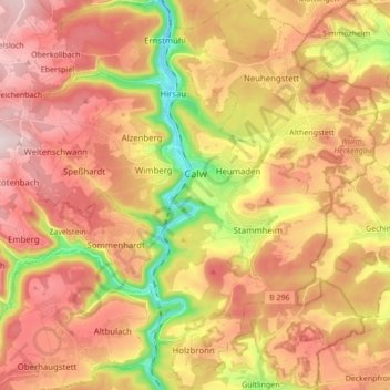
Name: Calw topographic map, elevation, terrain.
Average elevation: 1,772 ft
Minimum elevation: 1,063 ft
Maximum elevation: 2,300 ft
Other topographic maps
Click on a map to view its topography, its elevation and its terrain.
Affolter
Germany > Baden-Württemberg > Landkreis Calw > Nagold > Pfrondorf
Average elevation: 1,650 ft
Zieflensberg
Germany > Baden-Württemberg > Landkreis Calw > Bad Herrenalb > Zieflensberg
Average elevation: 2,192 ft
Bad Teinach
Germany > Baden-Württemberg > Landkreis Calw
The township (Stadt) of Bad Teinach-Zavelstein is located at the center of the district of Calw, in Baden-Württemberg, one of the 16 States of the Federal Republic of Germany. Bad Teinach-Zavelstein's municipal area rests upon the plateau of the Enz and Nagold rivers, a landscape defined by severe river…
Average elevation: 1,827 ft