
Make a donation
Gear up for your next adventure:
As an Amazon Associate, this site earns from qualifying purchases at no extra cost to you.
Monte Genevris topographic map
Click on the map to display elevation.
Make a donation
Gear up for your next adventure:
As an Amazon Associate, this site earns from qualifying purchases at no extra cost to you.
About this map
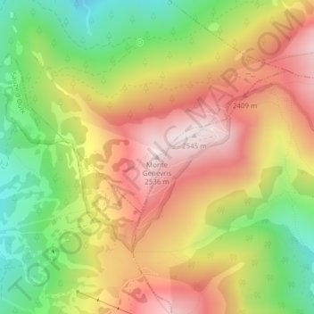
Name: Monte Genevris topographic map, elevation, terrain.
Location: Monte Genevris, Oulx, Torino, Piemonte, Italia (45.03091 6.90181 45.03101 6.90191)
Average elevation: 7,251 ft
Minimum elevation: 6,145 ft
Maximum elevation: 8,294 ft
Make a donation
Gear up for your next adventure:
As an Amazon Associate, this site earns from qualifying purchases at no extra cost to you.
Other topographic maps
Click on a map to view its topography, its elevation and its terrain.
Val di Susa
Italia > Piemonte > Torino > Oulx
La Val di Susa ospita una fauna ricca di varietà. I mammiferi sono di tipo medio-europeo e sono costituiti soprattutto da micromammiferi. Fra questi si segnalano varie specie di toporagno e di topi, il moscardino, il quercino e le arvicole. Sono presenti anche il riccio europeo occidentale e la talpa europea.…
Average elevation: 6,014 ft