
Make a donation
Gear up for your next adventure:
As an Amazon Associate, this site earns from qualifying purchases at no extra cost to you.
Allevard topographic map
Click on the map to display elevation.
Make a donation
Gear up for your next adventure:
As an Amazon Associate, this site earns from qualifying purchases at no extra cost to you.
Allevard
The commune has a ski resort: the Collet d'Allevard which is located 10 km from the town (30 minutes drive). The altitude of the runs varies from 1,450m to 2,100m. The resort has 35 km of runs: 7 green, 6 blue, 5 red, and 3 black.
Make a donation
Gear up for your next adventure:
As an Amazon Associate, this site earns from qualifying purchases at no extra cost to you.
About this map
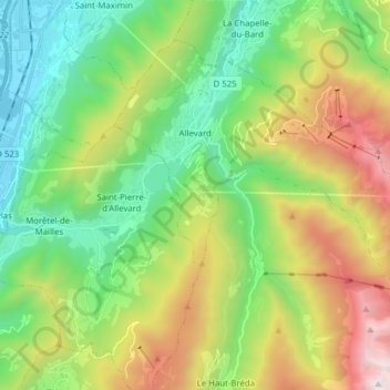
Name: Allevard topographic map, elevation, terrain.
Average elevation: 3,225 ft
Minimum elevation: 781 ft
Maximum elevation: 7,874 ft
Make a donation
Gear up for your next adventure:
As an Amazon Associate, this site earns from qualifying purchases at no extra cost to you.
Other topographic maps
Click on a map to view its topography, its elevation and its terrain.
La Bérarde
France > Auvergne-Rhône-Alpes > Isère > Saint-Christophe-en-Oisans
Average elevation: 7,569 ft