Geolocate

Roc topographic map

Click on the map to display elevation.

About this map

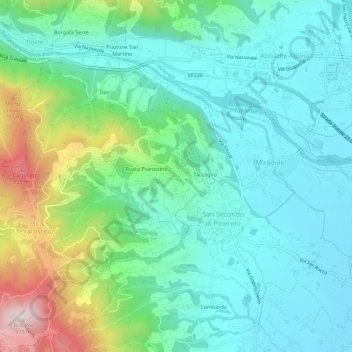
Name: Roc topographic map, elevation, terrain.

Location: Roc, Prarostino, Torino, Piedmont, 10060, Italy (44.85205 7.27063 44.89205 7.31063)

Average elevation: 1,673 ft

Minimum elevation: 1,181 ft

Maximum elevation: 3,159 ft

Gear up for your next adventure:

🔌Solar Panel Charger - Charge gear sustainably outdoors
🥇GPS Hiking Watch - Multi‑sport GPS watch with navigation and trail tracking
🧴Hand Sanitizer - Keep hands clean while hiking
💧Water Filtration Bottles - Safely drink from streams and lakes while exploring
🚁Photography Drones - Capture stunning aerial views of landforms and topography

As an Amazon Associate, this site earns from qualifying purchases at no extra cost to you.