
Richfield topographic map
Click on the map to display elevation.
Richfield
Richfield experiences a cold semi-arid climate (Köppen BSk) with four distinct seasons. Winter high temperatures average in the 30s and 40s with many milder days; low temperatures average in the teens and twenties, with a few mornings starting near or below zero. Snowfall is common, but usually melts in a day or two; however, deeper lasting snow cover is not uncommon. Still, December and January average among Richfield's drier months. Summer days are warm, with normal July highs in the 90s and occasional hot spells that near 100 °F or 37.8 °C. Nighttime temperatures during the summer are comfortable—usually in the 50s or 60s. From July through September, “monsoonal” thunderstorms frequently form over the nearby peaks contributing to over a third of the 8.12 inches or 206.2 millimetres of annual rainfall. Because of its low humidity and mile-high altitude, the Sevier Valley experiences its average first frost by late September and its last in late May, despite the typically warm fall and spring days. Richfield's record high is 104 °F (40 °C), set on July 23, 1931, and July 13–14, 1939, and the record low is −33 °F (−36.1 °C), set on February 6, 1989.
About this map
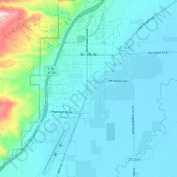
Name: Richfield topographic map, elevation, terrain.
Location: Richfield, Sevier County, Utah, United States (38.72436 -112.11753 38.79362 -112.06645)
Average elevation: 5,443 ft
Minimum elevation: 5,246 ft
Maximum elevation: 6,670 ft
Sevier County trails, hiking, mountain biking, running and outdoor activities
Other topographic maps
Click on a map to view its topography, its elevation and its terrain.