Geolocate

Mathias topographic map

Click on the map to display elevation.

About this map

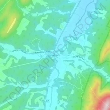
Name: Mathias topographic map, elevation, terrain.

Location: Mathias, Hardy County, West Virginia, United States (38.85631 -78.88579 38.89631 -78.84579)

Average elevation: 1,719 ft

Minimum elevation: 1,460 ft

Maximum elevation: 2,772 ft

Other topographic maps

Click on a map to view its topography, its elevation and its terrain.

Lost River

United States > West Virginia > Hardy County > Mathias

Average elevation: 1,650 ft

Trout Pond

United States > West Virginia > Hardy County

Average elevation: 2,156 ft

Wardensville

United States > West Virginia > Hardy County

Average elevation: 1,076 ft

Moorefield

United States > West Virginia > Hardy County

Average elevation: 856 ft

Wardensville

United States > West Virginia > Hardy County

Average elevation: 1,076 ft

Lost River

United States > West Virginia > Hardy County > Mathias

Average elevation: 1,654 ft

Moorefield

United States > West Virginia > Hardy County

Average elevation: 856 ft

Gear up for your next adventure:

🛡️Insect Repellent - Protection against bugs during outdoor activities
🧯Portable Fire Pit - Compact fire pit for camping spots
🧢Sun Protection Hats - Wide-brimmed and UPF-rated hats for high-altitude sun safety
🧭Orienteering Set - Complete compass and map reading kit
GPS Sports Watch - GPS watch for running, hiking and training

As an Amazon Associate, this site earns from qualifying purchases at no extra cost to you.