Geolocate

Anacapri topographic map

Click on the map to display elevation.

About this map

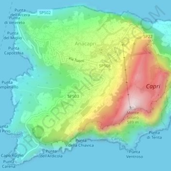
Name: Anacapri topographic map, elevation, terrain.

Location: Anacapri, Napoli, Campania, 80071, Italy (40.53588 14.19576 40.56185 14.23240)

Average elevation: 515 ft

Minimum elevation: 0 ft

Maximum elevation: 1,870 ft

Other topographic maps

Click on a map to view its topography, its elevation and its terrain.

Corricella

Italy > Campania > Napoli > Procida

Average elevation: 20 ft

Sentiero del Grande Cono

Italy > Campania > Napoli > Ercolano

Average elevation: 2,733 ft

Sorgente Acqua Santa

Italy > Campania > Napoli > Pimonte

Average elevation: 3,232 ft

Botanical Garden of Naples

Italy > Campania > Napoli > Naples

Average elevation: 213 ft

Nuova Colmata

Italy > Campania > Napoli > Pozzuoli

Average elevation: 75 ft

Masseria Curato

Italy > Campania > Napoli > Pompei > Masseria Curato

Average elevation: 43 ft

Gear up for your next adventure:

🥄Camping Utensil Set - Lightweight utensils for outdoor meals
🗻Climbing Gear Basics - Essential gear for beginner climbers
📖Nature Tracking Books - Learn to track wildlife and terrain
👟Men's Trail Runners - Lightweight footwear for fast-paced exploration and light hiking
🔋Rechargeable Batteries - Power up your outdoor devices

As an Amazon Associate, this site earns from qualifying purchases at no extra cost to you.