Geolocate

Valsad topographic map

Click on the map to display elevation.

Valsad

Valsad is located at 20°38′N 72°56′E / 20.63°N 72.93°E / 20.63; 72.93. It has an average elevation of 13 metres (42 feet). The old city is about 4 km inland from the Arabian Sea.

Wikipedia (CC-BY-SA 3.0)

About this map

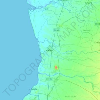
Name: Valsad topographic map, elevation, terrain.

Location: Valsad, Valsad Taluka, Valsad, Gujarat, 395125, India (20.44678 72.76729 20.76678 73.08729)

Average elevation: 52 ft

Minimum elevation: -10 ft

Maximum elevation: 505 ft

Gear up for your next adventure:

🌲Outdoor Survival Books - Best books on survival skills
🧢Outdoor Hiking Hat - Sun protection hat for outdoor explorers
🌧️Backpack Rain Cover - Keep gear dry in wet weather
🏥Hiking First Aid Kits - Comprehensive medical kits for remote trail injuries
🔪Outdoor Multitools - Essential survival tools for gear repair and field use

As an Amazon Associate, this site earns from qualifying purchases at no extra cost to you.