
Harkaway topographic map
Interactive map
Click on the map to display elevation.
About this map
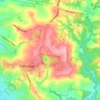
Name: Harkaway topographic map, elevation, terrain.
Location: Harkaway, City of Casey, Victoria, Australia (-38.01304 145.32333 -37.97205 145.38524)
Average elevation: 423 ft
Minimum elevation: 167 ft
Maximum elevation: 702 ft
Other topographic maps
Click on a map to view its topography, its elevation and its terrain.
Narre Warren
Australia > Victoria > Harkaway
Narre Warren, Harkaway, City of Casey, Victoria, Australia
Average elevation: 138 ft
Basalt Lake
Australia > Victoria > Harkaway
Basalt Lake, Board Walk, Berwick, Harkaway, City of Casey, Victoria, 3806, Australia
Average elevation: 249 ft
Timbarra Park
Australia > Victoria > Harkaway
Timbarra Park, Berwick, Harkaway, City of Casey, Victoria, Australia
Average elevation: 220 ft