
Make a donation
Gear up for your next adventure:
As an Amazon Associate, this site earns from qualifying purchases at no extra cost to you.
Kotagala topographic map
Click on the map to display elevation.
Make a donation
Gear up for your next adventure:
As an Amazon Associate, this site earns from qualifying purchases at no extra cost to you.
Kotagala
Kotagala is a small town in the Nuwara Eliya District of the Central Province, Sri Lanka. It is located 35.8 km (22.2 mi) from Nuwara Eliya at an elevation of 1,247 m (4,091 ft) above sea level.
Make a donation
Gear up for your next adventure:
As an Amazon Associate, this site earns from qualifying purchases at no extra cost to you.
About this map
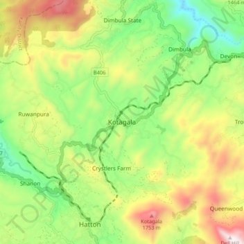
Name: Kotagala topographic map, elevation, terrain.
Average elevation: 4,354 ft
Minimum elevation: 3,097 ft
Maximum elevation: 6,129 ft
Make a donation
Gear up for your next adventure:
As an Amazon Associate, this site earns from qualifying purchases at no extra cost to you.
Other topographic maps
Click on a map to view its topography, its elevation and its terrain.
Make a donation
Gear up for your next adventure:
As an Amazon Associate, this site earns from qualifying purchases at no extra cost to you.
upper division, north meddecombra
Sri Lanka > Central Province > upper division, north meddecombra
Average elevation: 4,160 ft