
Thank you for supporting this site ❤️
Make a donation
Make a donation
Gear up for your next adventure:
As an Amazon Associate, this site earns from qualifying purchases at no extra cost to you.
Porcuya topographic map
Click on the map to display elevation.
Thank you for supporting this site ❤️
Make a donation
Make a donation
Gear up for your next adventure:
As an Amazon Associate, this site earns from qualifying purchases at no extra cost to you.
About this map
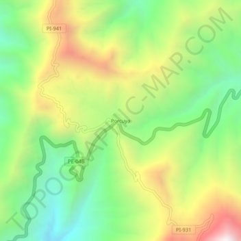
Name: Porcuya topographic map, elevation, terrain.
Location: Porcuya, Huarmaca, Huancabamba, Piura, Perú (-5.85956 -79.52458 -5.81956 -79.48458)
Average elevation: 7,073 ft
Minimum elevation: 5,371 ft
Maximum elevation: 9,505 ft
Thank you for supporting this site ❤️
Make a donation
Make a donation
Gear up for your next adventure:
As an Amazon Associate, this site earns from qualifying purchases at no extra cost to you.