Geolocate

Lower Higham topographic map

Click on the map to display elevation.

About this map

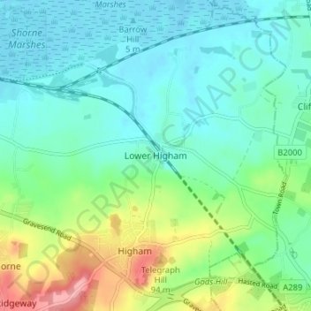
Name: Lower Higham topographic map, elevation, terrain.

Location: Lower Higham, Gravesham, Kent, England, ME3 7LU, United Kingdom (51.40737 0.44404 51.44737 0.48404)

Average elevation: 92 ft

Minimum elevation: -10 ft

Maximum elevation: 354 ft

Other topographic maps

Click on a map to view its topography, its elevation and its terrain.

Gravesend

United Kingdom > England > Kent > Gravesham

Average elevation: 102 ft

Northfleet

United Kingdom > England > Kent > Gravesham

Average elevation: 108 ft

Gravesend

United Kingdom > England > Kent > Gravesham

Average elevation: 102 ft

Northfleet

United Kingdom > England > Kent > Gravesham

Average elevation: 108 ft

Northfleet

United Kingdom > England > Kent > Gravesham

Average elevation: 108 ft

Luddesdown

United Kingdom > England > Kent > Gravesham

Average elevation: 358 ft

Gravesend

United Kingdom > England > Kent > Gravesham

Average elevation: 102 ft

Shorne Wood

United Kingdom > England > Kent > Gravesham > Shorne Ridgeway

Average elevation: 272 ft

Robins Creek

United Kingdom > England > Kent > Gravesham > Northfleet

Average elevation: 33 ft

Meopham

United Kingdom > England > Kent > Gravesham > Meopham

Average elevation: 407 ft

Vigo

United Kingdom > England > Kent > Gravesham

Average elevation: 525 ft

Meopham

United Kingdom > England > Kent > Gravesham > Meopham

Average elevation: 407 ft

Shorne

United Kingdom > England > Kent > Gravesham > Higham

Average elevation: 115 ft

Gear up for your next adventure:

🪶Trail Camera - Capture wildlife on your hikes
🔋Solar Power Banks - Keep your GPS and phone charged in remote wilderness areas
🧭GPS Watch Accessories - Bands and chargers for GPS watches
🧢Outdoor Hiking Hat - Sun protection hat for outdoor explorers
🎒Hydration Pack - Hands‑free water reservoir for long hikes

As an Amazon Associate, this site earns from qualifying purchases at no extra cost to you.