
Make a donation
Gear up for your next adventure:
As an Amazon Associate, this site earns from qualifying purchases at no extra cost to you.
Chubut Province topographic map
Click on the map to display elevation.
Make a donation
Gear up for your next adventure:
As an Amazon Associate, this site earns from qualifying purchases at no extra cost to you.
Chubut Province
Chubut stretches from the Atlantic to the Andes with 3 distinct environmental regions: The Andes, the central plains and the coastal regions. The Andes in the westernmost parts of the province mostly extend along the Chilean border. The Andes are not that high in Chubut, with most peaks averaging around 1,500 and 2,000 metres (4,900 and 6,600 ft), which becomes smaller in altitude in the southern parts. The highest peak is Cerro Dos Picos, located east of Lago Cholila with a height of 2,515 metres (8,251 ft). The Andes in this province are of tertiary origin and are separated by wide, deep transverse valleys that are oriented in an east–west direction. These valleys are occupied by glacial lakes and rivers flowing east from the mountains. Most of these valleys existed before the Andes were formed. The lakes, which are mostly located in the western parts of the province are of glacial origin because during the last ice age, the movement of the glaciers lead to the formation of extensive areas of depressions that were filled up with water to form the lakes today.
Make a donation
Gear up for your next adventure:
As an Amazon Associate, this site earns from qualifying purchases at no extra cost to you.
About this map
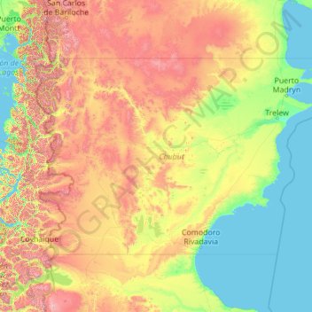
Name: Chubut Province topographic map, elevation, terrain.
Location: Chubut Province, Argentina (-46.00002 -72.18782 -41.99203 -63.31159)
Average elevation: 1,824 ft
Minimum elevation: 0 ft
Maximum elevation: 10,203 ft
Make a donation
Gear up for your next adventure:
As an Amazon Associate, this site earns from qualifying purchases at no extra cost to you.
Other topographic maps
Click on a map to view its topography, its elevation and its terrain.
San Juan
San Juan is ranked second among the wine-producing provinces of Argentina. It has a cultivated area of 116,700 acres at altitudes of between 1,970 (601m) and 4,590 feet (1399m) above sea level. This region specializes in Syrah, Malbec, Cabernet Sauvignon, Bonarda, Chardonnay and Torrontés. Because of this…
Average elevation: 2,277 ft
Make a donation
Gear up for your next adventure:
As an Amazon Associate, this site earns from qualifying purchases at no extra cost to you.
Make a donation
Gear up for your next adventure:
As an Amazon Associate, this site earns from qualifying purchases at no extra cost to you.