
Make a donation
Gear up for your next adventure:
As an Amazon Associate, this site earns from qualifying purchases at no extra cost to you.
Grudziądz topographic map
Click on the map to display elevation.
Make a donation
Gear up for your next adventure:
As an Amazon Associate, this site earns from qualifying purchases at no extra cost to you.
About this map
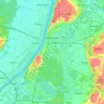
Name: Grudziądz topographic map, elevation, terrain.
Location: Grudziądz, Kuyavian-Pomeranian Voivodeship, Poland (53.42077 18.68607 53.52415 18.87091)
Average elevation: 98 ft
Minimum elevation: 36 ft
Maximum elevation: 299 ft
Make a donation
Gear up for your next adventure:
As an Amazon Associate, this site earns from qualifying purchases at no extra cost to you.
Other topographic maps
Click on a map to view its topography, its elevation and its terrain.
Gardęga
Poland > Kuyavian-Pomeranian Voivodeship > Grudziądz County > Sobótka
Average elevation: 279 ft
Make a donation
Gear up for your next adventure:
As an Amazon Associate, this site earns from qualifying purchases at no extra cost to you.
Kwaśniewo
Poland > Kuyavian-Pomeranian Voivodeship > Świecie County > Sulnowo
Average elevation: 259 ft