Geolocate

Nellimattom topographic map

Click on the map to display elevation.

About this map

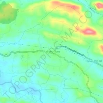
Name: Nellimattom topographic map, elevation, terrain.

Location: Nellimattom, Kothamangalam, Ernakulam District, Kerala, India (10.03844 76.66262 10.07844 76.70262)

Average elevation: 177 ft

Minimum elevation: 59 ft

Maximum elevation: 466 ft

Other topographic maps

Click on a map to view its topography, its elevation and its terrain.

Erappunkal VCB

India > Kerala > Kothamangalam

Average elevation: 108 ft

Eravikulam National Park

India > Kerala > Kothamangalam > Idukki

Average elevation: 5,591 ft

Gear up for your next adventure:

🎒Day Hiking Backpack - Lightweight backpack perfect for day trips and outdoor adventures
🏥Hiking First Aid Kits - Comprehensive medical kits for remote trail injuries
🌐World Map Poster - Decorative world maps with topographic info
🧦Merino Wool Socks - Moisture-wicking, blister-preventing socks for long treks
📦Gear Storage Bags - Organize and protect outdoor equipment

As an Amazon Associate, this site earns from qualifying purchases at no extra cost to you.