Geolocate

Wurlitz topographic map

Click on the map to display elevation.

About this map

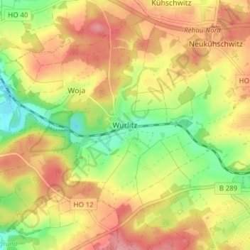
Name: Wurlitz topographic map, elevation, terrain.

Location: Wurlitz, Rehau, Landkreis Hof, Bayern, 95111, Deutschland (50.23359 11.96994 50.27359 12.00994)

Average elevation: 1,785 ft

Minimum elevation: 1,608 ft

Maximum elevation: 1,936 ft

Gear up for your next adventure:

🧺Microfiber Travel Towels - Compact and fast-drying towels for trail use
🦺Reflective Outdoor Gear - Safety gear for low‑light conditions
🖼️Topo Map Wall Art - Decorative topographic prints of famous peaks and regions
📚Navigation Handbooks - Master the art of reading topographic maps and using a compass
🎒Waterproof Dry Bags - Keep your electronics and maps dry inside your pack

As an Amazon Associate, this site earns from qualifying purchases at no extra cost to you.