
Make a donation
Gear up for your next adventure:
As an Amazon Associate, this site earns from qualifying purchases at no extra cost to you.
Umuarama topographic map
Click on the map to display elevation.
Make a donation
Gear up for your next adventure:
As an Amazon Associate, this site earns from qualifying purchases at no extra cost to you.
Umuarama
Umuarama is a municipality in the state of Paraná in Brazil. Its population was 112,500 inhabitants in 2020. Umuarama is one of the most important cities in Paraná, one of the three states of southern Brazil. The city elevation is 430 m (1,300 feet) above sea level and the rainfall is about 1600mm/year (63 inches/yr). Umuarama is known as "The Capital of Friendship".
Make a donation
Gear up for your next adventure:
As an Amazon Associate, this site earns from qualifying purchases at no extra cost to you.
About this map
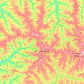
Name: Umuarama topographic map, elevation, terrain.
Average elevation: 1,237 ft
Minimum elevation: 853 ft
Maximum elevation: 1,677 ft
Make a donation
Gear up for your next adventure:
As an Amazon Associate, this site earns from qualifying purchases at no extra cost to you.
Other topographic maps
Click on a map to view its topography, its elevation and its terrain.