
Make a donation
Gear up for your next adventure:
As an Amazon Associate, this site earns from qualifying purchases at no extra cost to you.
Teresita topographic map
Click on the map to display elevation.
Make a donation
Gear up for your next adventure:
As an Amazon Associate, this site earns from qualifying purchases at no extra cost to you.
About this map
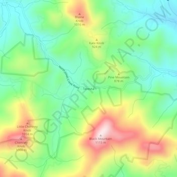
Name: Teresita topographic map, elevation, terrain.
Location: Teresita, Macon County, North Carolina, United States (35.08287 -83.47043 35.12287 -83.43043)
Average elevation: 2,700 ft
Minimum elevation: 2,142 ft
Maximum elevation: 3,638 ft
Macon County trails, hiking, mountain biking, running and outdoor activities
Make a donation
Gear up for your next adventure:
As an Amazon Associate, this site earns from qualifying purchases at no extra cost to you.
Other topographic maps
Click on a map to view its topography, its elevation and its terrain.
Little Tennessee River
United States > North Carolina > Macon County > Franklin > East Franklin
Average elevation: 2,103 ft