Geolocate

Poggibonsi topographic map

Click on the map to display elevation.

About this map

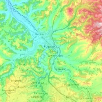
Name: Poggibonsi topographic map, elevation, terrain.

Location: Poggibonsi, Siena, Tuscany, 53036, Italy (43.40145 11.08749 43.52267 11.22401)

Average elevation: 620 ft

Minimum elevation: 236 ft

Maximum elevation: 1,440 ft

Other topographic maps

Click on a map to view its topography, its elevation and its terrain.

View on hills and ‘drunk’ roads

Italy > Tuscany > Siena > Pienza

Average elevation: 1,273 ft

Santa Chiara

Italy > Tuscany > Siena > San Gimignano

Average elevation: 837 ft

Bettolle

Italy > Tuscany > Siena > Sinalunga

Average elevation: 853 ft

Modena

Italy > Tuscany > Siena > Sovicille > Recenza

Average elevation: 1,047 ft

Gear up for your next adventure:

🧭Orienteering Set - Complete compass and map reading kit
🪄Magnetic Compass - Accurate compass for navigation
🦶Carbon Trekking Poles - Reduce knee impact on steep descents with ultra-light poles
📶Vehicle Signal Boosters - Improve reception in rural areas while driving to trailheads
📡GPS Antenna Upgrade - Enhance GPS reception in remote terrain

As an Amazon Associate, this site earns from qualifying purchases at no extra cost to you.