
Santa Lucía topographic map
Interactive map
Click on the map to display elevation.
About this map
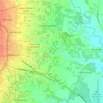
Name: Santa Lucía topographic map, elevation, terrain.
Location: Santa Lucía, San Juan, Argentine (-31.57854 -68.51009 -31.49729 -68.41322)
Average elevation: 1,985 ft
Minimum elevation: 1,926 ft
Maximum elevation: 2,070 ft
Other topographic maps
Click on a map to view its topography, its elevation and its terrain.
Laguna Grande de Arena
Laguna Grande de Arena, Calingasta, San Juan, Argentine
Average elevation: 10,561 ft