
Make a donation
Gear up for your next adventure:
As an Amazon Associate, this site earns from qualifying purchases at no extra cost to you.
Hillsboro topographic map
Click on the map to display elevation.
Make a donation
Gear up for your next adventure:
As an Amazon Associate, this site earns from qualifying purchases at no extra cost to you.
About this map
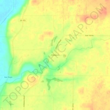
Name: Hillsboro topographic map, elevation, terrain.
Location: Hillsboro, Henry County, Indiana, United States (39.94810 -85.35164 39.98810 -85.31164)
Average elevation: 1,070 ft
Minimum elevation: 981 ft
Maximum elevation: 1,119 ft
Henry County trails, hiking, mountain biking, running and outdoor activities
Make a donation
Gear up for your next adventure:
As an Amazon Associate, this site earns from qualifying purchases at no extra cost to you.
Other topographic maps
Click on a map to view its topography, its elevation and its terrain.
Mount Summit
United States > Indiana > Henry County
Mount Summit was platted in 1854. It was named for its lofty elevation. A post office has been in operation in Mount Summit since 1869.
Average elevation: 1,083 ft
Make a donation
Gear up for your next adventure:
As an Amazon Associate, this site earns from qualifying purchases at no extra cost to you.
Make a donation
Gear up for your next adventure:
As an Amazon Associate, this site earns from qualifying purchases at no extra cost to you.