Geolocate

Pamulang topographic map

Click on the map to display elevation.

About this map

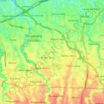
Name: Pamulang topographic map, elevation, terrain.

Location: Pamulang, South Tangerang, Banten, Java, Indonesia (-6.36206 106.69935 -6.30440 106.77902)

Average elevation: 180 ft

Minimum elevation: 89 ft

Maximum elevation: 269 ft

Other topographic maps

Click on a map to view its topography, its elevation and its terrain.

Sutera Olivia

Indonesia > Banten > South Tangerang

Average elevation: 82 ft

Virginia Lagoon

Indonesia > Banten > South Tangerang

Average elevation: 112 ft

Baruasih

Indonesia > Banten > South Tangerang

Average elevation: 154 ft

Cadasmampar

Indonesia > Banten > South Tangerang

Average elevation: 138 ft

Cadasmampar

Indonesia > Banten > South Tangerang

Average elevation: 138 ft

Cadasmampar

Indonesia > Banten > South Tangerang > Serpong

Average elevation: 138 ft

Cadasmampar

Indonesia > Banten > South Tangerang

Average elevation: 138 ft

Pamulang

Indonesia > Banten > South Tangerang

Average elevation: 200 ft

De Latinos

Indonesia > Banten > South Tangerang

Average elevation: 151 ft

BSD

Indonesia > Banten > South Tangerang

Average elevation: 108 ft

Pamulang

Indonesia > Banten > South Tangerang

Average elevation: 200 ft

BSD

Indonesia > Banten > South Tangerang

Average elevation: 108 ft

BSD

Indonesia > Banten > South Tangerang

Average elevation: 108 ft

Caribbean Islands

Indonesia > Banten > South Tangerang

Average elevation: 157 ft

Gear up for your next adventure:

☀️Outdoor Sunscreen - High protection sunscreen for outdoor activities
📚Navigation Handbooks - Master the art of reading topographic maps and using a compass
👟Trail Running Shoes - Lightweight shoes for trail runners
📡GPS Antenna Upgrade - Enhance GPS reception in remote terrain
🛡️Bear Spray Outdoor - Protection in bear country hikes

As an Amazon Associate, this site earns from qualifying purchases at no extra cost to you.