Geolocate

Irawo topographic map

Click on the map to display elevation.

About this map

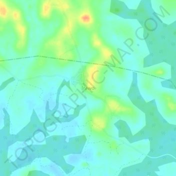
Name: Irawo topographic map, elevation, terrain.

Location: Irawo, Ijebu Ode, Ogun State, Nigeria (6.70326 4.01566 6.74326 4.05566)

Average elevation: 59 ft

Minimum elevation: 26 ft

Maximum elevation: 148 ft

Gear up for your next adventure:

🏫Relief Map Kits - Hands-on tools for teaching landforms and elevation
💧Water Filtration Bottles - Safely drink from streams and lakes while exploring
🧭Outdoor Navigation Book - Learn advanced navigation skills
🌡️Handheld Weather Meters - Measure wind, temp, and pressure for safe mountain travel
🚪Portable Camp Chair - Foldable chair for comfort at camp

As an Amazon Associate, this site earns from qualifying purchases at no extra cost to you.