Geolocate

Dorset topographic map

Click on the map to display elevation.

About this map

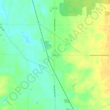
Name: Dorset topographic map, elevation, terrain.

Location: Dorset, Ashtabula County, Ohio, 44032, United States (41.66033 -80.68730 41.70033 -80.64730)

Average elevation: 988 ft

Minimum elevation: 942 ft

Maximum elevation: 1,037 ft

Ashtabula County trails, hiking, mountain biking, running and outdoor activities

Other topographic maps

Click on a map to view its topography, its elevation and its terrain.

Jefferson

United States > Ohio > Ashtabula County

Average elevation: 935 ft

Roaming Shores

United States > Ohio > Ashtabula County

Average elevation: 883 ft

Rock Creek

United States > Ohio > Ashtabula County

Average elevation: 814 ft

Edgewood

United States > Ohio > Ashtabula County

Average elevation: 702 ft

North Kingsville

United States > Ohio > Ashtabula County

Average elevation: 650 ft

New Lyme Township

United States > Ohio > Ashtabula County

Average elevation: 994 ft

Ashtabula

United States > Ohio > Ashtabula County

Average elevation: 656 ft

Conneaut

United States > Ohio > Ashtabula County

Average elevation: 696 ft

Geneva

United States > Ohio > Ashtabula County

Average elevation: 591 ft

Gear up for your next adventure:

👓Polarized Sunglasses - Outdoor sunglasses for glare reduction
🧦Hiking Socks - Comfortable socks to prevent blisters on long hikes
🌡️Portable Weather Meter - Track weather conditions on the trail
🎒Trekking Poles - Sturdy poles for balance and stability on rough terrain
🪶Trail Camera - Capture wildlife on your hikes

As an Amazon Associate, this site earns from qualifying purchases at no extra cost to you.