
Make a donation
Gear up for your next adventure:
As an Amazon Associate, this site earns from qualifying purchases at no extra cost to you.
Magic Lake topographic map
Click on the map to display elevation.
Make a donation
Gear up for your next adventure:
As an Amazon Associate, this site earns from qualifying purchases at no extra cost to you.
About this map
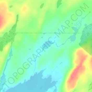
Name: Magic Lake topographic map, elevation, terrain.
Average elevation: 1,850 ft
Minimum elevation: 1,772 ft
Maximum elevation: 1,995 ft
Cook County trails, hiking, mountain biking, running and outdoor activities
Make a donation
Gear up for your next adventure:
As an Amazon Associate, this site earns from qualifying purchases at no extra cost to you.
Other topographic maps
Click on a map to view its topography, its elevation and its terrain.
Grand Portage National Monument
United States > Minnesota > Cook County
The portage begins on Lake Superior, elevation 600 feet (180 m), rising as it moves westward through two notches in the Sawtooth Mountain range. It briefly levels off around 1,000 feet (300 m) after 2.6 miles (4.2 km). Another 1.5 miles (2.4 km) you reach the inland county highway. From here, the trail is more…
Average elevation: 1,030 ft
Make a donation
Gear up for your next adventure:
As an Amazon Associate, this site earns from qualifying purchases at no extra cost to you.