
Make a donation
Gear up for your next adventure:
As an Amazon Associate, this site earns from qualifying purchases at no extra cost to you.
Hille topographic map
Click on the map to display elevation.
Make a donation
Gear up for your next adventure:
As an Amazon Associate, this site earns from qualifying purchases at no extra cost to you.
Hille
Das Gemeindegebiet ist 102,99 km² groß und umfasst neben dem Flachland der Norddeutschen Tiefebene mit dem niedrigsten Punkt auf 45,7 m Höhe den am südlichen Rand zum Wiehengebirge ansteigenden Teil mit bis zu 261 Meter Höhe.
Make a donation
Gear up for your next adventure:
As an Amazon Associate, this site earns from qualifying purchases at no extra cost to you.
About this map
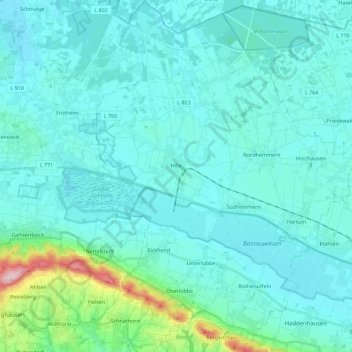
Name: Hille topographic map, elevation, terrain.
Average elevation: 230 ft
Minimum elevation: 128 ft
Maximum elevation: 1,014 ft
Make a donation
Gear up for your next adventure:
As an Amazon Associate, this site earns from qualifying purchases at no extra cost to you.
Other topographic maps
Click on a map to view its topography, its elevation and its terrain.
Kappenberg
Deutschland > Nordrhein-Westfalen > Kreis Minden-Lübbecke > Bad Oeynhausen
Average elevation: 390 ft
Nettelstedt
Deutschland > Nordrhein-Westfalen > Kreis Minden-Lübbecke > Lübbecke
Average elevation: 361 ft
Babbenhausen
Deutschland > Nordrhein-Westfalen > Kreis Minden-Lübbecke > Bad Oeynhausen
Average elevation: 272 ft