
Thank you for supporting this site ❤️
Make a donation
Make a donation
Gear up for your next adventure:
As an Amazon Associate, this site earns from qualifying purchases at no extra cost to you.
Cabanelles topographic map
Click on the map to display elevation.
Thank you for supporting this site ❤️
Make a donation
Make a donation
Gear up for your next adventure:
As an Amazon Associate, this site earns from qualifying purchases at no extra cost to you.
About this map
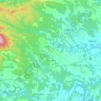
Name: Cabanelles topographic map, elevation, terrain.
Location: Cabanelles, Alt Empordà, Gerona, Catalonië, 17746, Spanje (42.17919 2.71329 42.30609 2.86129)
Average elevation: 676 ft
Minimum elevation: 177 ft
Maximum elevation: 2,969 ft
Thank you for supporting this site ❤️
Make a donation
Make a donation
Gear up for your next adventure:
As an Amazon Associate, this site earns from qualifying purchases at no extra cost to you.
Other topographic maps
Click on a map to view its topography, its elevation and its terrain.
El Port de la Selva
Spanje > Catalonië > Alt Empordà > el Port de la Selva > El Port de la Selva
Average elevation: 249 ft