
Make a donation
Gear up for your next adventure:
As an Amazon Associate, this site earns from qualifying purchases at no extra cost to you.
Seymour topographic map
Click on the map to display elevation.
Make a donation
Gear up for your next adventure:
As an Amazon Associate, this site earns from qualifying purchases at no extra cost to you.
Seymour
The climate is humid subtropical (Köppen: Cfa) with an extreme temperature deviation, but much of the time, the variation is always more and the warm weather prevails over the cold as the averages and the records show. Its subtropical location and south of the center of a large land mass bring occasional outbreaks even to a latitude and not very high altitude. The climate in this area is characterized by hot, humid summers and generally mild to cool winters, sometimes cold. On August 12, 1936, Seymour witnessed the record highest temperature in Texas (120 °F) (49 °C), a record that was tied by the city of Monahans on June 28, 1994.
Make a donation
Gear up for your next adventure:
As an Amazon Associate, this site earns from qualifying purchases at no extra cost to you.
About this map
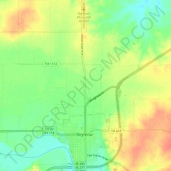
Name: Seymour topographic map, elevation, terrain.
Location: Seymour, Baylor County, Texas, 76380, United States (33.57758 -99.28730 33.65528 -99.23953)
Average elevation: 1,316 ft
Minimum elevation: 1,243 ft
Maximum elevation: 1,398 ft
Baylor County trails, hiking, mountain biking, running and outdoor activities
Make a donation
Gear up for your next adventure:
As an Amazon Associate, this site earns from qualifying purchases at no extra cost to you.
Other topographic maps
Click on a map to view its topography, its elevation and its terrain.
Make a donation
Gear up for your next adventure:
As an Amazon Associate, this site earns from qualifying purchases at no extra cost to you.