Geolocate

Goubon topographic map

Interactive map

Click on the map to display elevation.

About this map

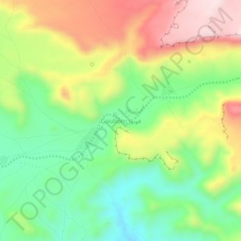
Name: Goubon topographic map, elevation, terrain.

Location: Goubon, Tibesti, Tchad (20.60400 17.15177 20.64400 17.19177)

Average elevation: 4,980 ft

Minimum elevation: 4,400 ft

Maximum elevation: 5,755 ft

Other topographic maps

Click on a map to view its topography, its elevation and its terrain.

Trou au Natron

Tchad > Tibesti

Trou au Natron, Tibesti, Tchad

Average elevation: 5,023 ft

إيمي كوسي Emi Koussi

Tchad > Tibesti

إيمي كوسي Emi Koussi, Tibesti, Tchad

Average elevation: 9,528 ft

Adaou

Tchad > Tibesti

Adaou, Tibesti, Tchad

Average elevation: 1,949 ft

Ehi Oyé

Tchad > Tibesti

Ehi Oyé, Tibesti, Tchad

Average elevation: 7,556 ft

تيبستي

Tchad > Tibesti

تيبستي, Tibesti, Tchad

Average elevation: 2,628 ft

Dossa

Tchad > Tibesti

Dossa, Tibesti, Tchad

Average elevation: 2,133 ft