
Make a donation
Gear up for your next adventure:
As an Amazon Associate, this site earns from qualifying purchases at no extra cost to you.
Meigermühle topographic map
Click on the map to display elevation.
Make a donation
Gear up for your next adventure:
As an Amazon Associate, this site earns from qualifying purchases at no extra cost to you.
Meigermühle
Meigermühle liegt im Südwesten von Lohmar. Umliegende Ortschaften und Weiler sind Hoverhof im Norden, Kirchscheid, Scheiderhöhe und Wielpütz im Nordosten, Besenbroich im Osten, Heppenberg, Donrath, Sottenbach und Pützrath im Südosten, Lohmar-Ort im Süden, Altenrath im Südwesten bis Westen sowie Helmgesmühle, Meigerhof und Feienberg im Nordwesten.
Make a donation
Gear up for your next adventure:
As an Amazon Associate, this site earns from qualifying purchases at no extra cost to you.
About this map
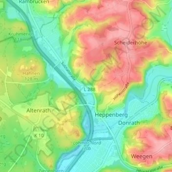
Name: Meigermühle topographic map, elevation, terrain.
Average elevation: 351 ft
Minimum elevation: 190 ft
Maximum elevation: 558 ft
Make a donation
Gear up for your next adventure:
As an Amazon Associate, this site earns from qualifying purchases at no extra cost to you.