Geolocate

Rothsay topographic map

Click on the map to display elevation.

About this map

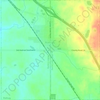
Name: Rothsay topographic map, elevation, terrain.

Location: Rothsay, Wilkin County, Minnesota, 56579, United States (46.45702 -96.30177 46.48634 -96.25958)

Average elevation: 1,214 ft

Minimum elevation: 1,155 ft

Maximum elevation: 1,299 ft

Wilkin County trails, hiking, mountain biking, running and outdoor activities

Gear up for your next adventure:

🌡️Handheld Weather Meters - Measure wind, temp, and pressure for safe mountain travel
🚗GPS Dash Cams - Record your scenic drives through mountain passes and canyons
🛠️Outdoor Gear Repair Kit - Essential tools to fix gear on the trail
🪶Camping Sleeping Pad - Comfortable sleeping pad for backpacking
🔥Camping Stove - Portable stove for camping and backcountry cooking

As an Amazon Associate, this site earns from qualifying purchases at no extra cost to you.