Geolocate

Champa topographic map

Click on the map to display elevation.

Champa

Champa has an average elevation of 253 metres (830 feet). It is located on the banks of Hasdeo river, a tributary of Mahanadi.

Wikipedia (CC-BY-SA 3.0)

About this map

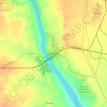
Name: Champa topographic map, elevation, terrain.

Location: Champa, Champa Tahsil, Janjgir-Champa District, Chhattisgarh, 495617, India (21.99084 82.60604 22.07084 82.68604)

Average elevation: 833 ft

Minimum elevation: 758 ft

Maximum elevation: 886 ft

Gear up for your next adventure:

🔭Telescopic Hiking Pole - Adjustable pole for hiking stability
🗺️Topographic Maps - Detailed topo maps for hiking, exploring and outdoor navigation
🔌Solar Panel Charger - Charge gear sustainably outdoors
🔪Outdoor Multitools - Essential survival tools for gear repair and field use
🔋Solar Power Banks - Keep your GPS and phone charged in remote wilderness areas

As an Amazon Associate, this site earns from qualifying purchases at no extra cost to you.