Geolocate

Wagholi topographic map

Click on the map to display elevation.

About this map

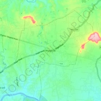
Name: Wagholi topographic map, elevation, terrain.

Location: Wagholi, Pune, Pune District, Maharashtra, 412207, India (18.54063 73.94331 18.62063 74.02331)

Average elevation: 1,896 ft

Minimum elevation: 1,732 ft

Maximum elevation: 2,329 ft

Other topographic maps

Click on a map to view its topography, its elevation and its terrain.

Indrayani

India > Maharashtra > Pune

Average elevation: 2,224 ft

Mula-Mutha River

India > Maharashtra > Pune > Khadki

Average elevation: 1,824 ft

Udaan Biodiversity Park

India > Maharashtra > Pune

Average elevation: 1,877 ft

Katraj Lake

India > Maharashtra > Pune > Katraj

Average elevation: 2,172 ft

Kamala Nehru Park

India > Maharashtra > Pune

Average elevation: 1,893 ft

Magarpatta City School Ground

India > Maharashtra > Pune

Average elevation: 1,864 ft

Chittranjan Vatika

India > Maharashtra > Pune

Average elevation: 1,883 ft

Gear up for your next adventure:

🗃️Trail First Aid Kit - Essential kit for outdoor injuries and emergencies
Camping Coffee Makers - Enjoy premium coffee at the summit or campsite
🌧️Backpack Rain Cover - Keep gear dry in wet weather
🍳Camping Cook Set - Complete cookware for outdoor meals
🌐World Map Poster - Decorative world maps with topographic info

As an Amazon Associate, this site earns from qualifying purchases at no extra cost to you.